The Log of Moira
Patagonia: Punta Arenas and Parque Torres del Paine, Chile (October 2007)
 These are mostly Susan’s remarks. Larry’s
notes are indicated thus <Larry: blah blah blah.>. All maps in this page
are courtesy of Wikipedia.
These are mostly Susan’s remarks. Larry’s
notes are indicated thus <Larry: blah blah blah.>. All maps in this page
are courtesy of Wikipedia.
We spent most of October exploring Patagonia, but not on Moira. We left Moira safely in Cartagena, Colombia at the Club de Pesca marina.
Physical Geography
 Patagonia
is a very large area, encompassing the southern parts of both Chile and
Argentina. In Argentina, the area extends southward from the peninsula Valdez
to the most southerly city in Argentina, Ushuaia, located on the Beagle Channel
on the island of Terra de Fuego. In Chile the area extends from Puerto Montt
southward to the tip of the continent, including the southernmost town in
Chile, Puerto Williams, and the island of Cape Horn.
Patagonia
is a very large area, encompassing the southern parts of both Chile and
Argentina. In Argentina, the area extends southward from the peninsula Valdez
to the most southerly city in Argentina, Ushuaia, located on the Beagle Channel
on the island of Terra de Fuego. In Chile the area extends from Puerto Montt
southward to the tip of the continent, including the southernmost town in
Chile, Puerto Williams, and the island of Cape Horn.
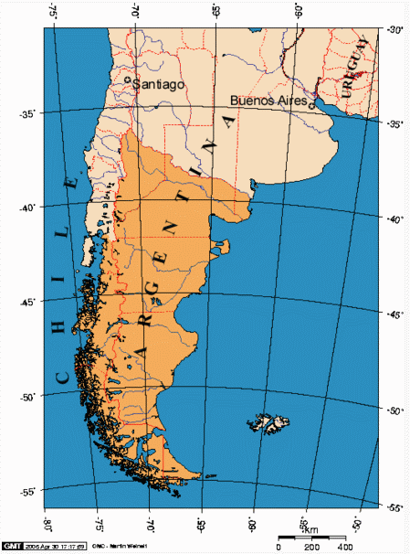
<Larry: The area defined by each country as “Patagonian” is highlighted in orange on the adjacent map. The twisty solid red line is the international boundary between Chile and Argentina. As you run your eye down from the north, notice how the border zig’s east to the Atlantic at about 52 degrees south, then zag’s south through the island of Tierra del Fuego.
Look at the map north-to-south. The contiguous continent ends at the Strait of Magellan, which runs a Z-shaped path at about 53-54 degrees south between the two oceans. With minor exception, Chile controls the land on both sides of the Strait. Between the Strait and the Beagle Channel are many dozens of islands, dominated by the big island of Tierra del Fuego to the southeast; Argentina and Chile divide ownership of Tierra del Fuego Island. South of Tierra del Fuego is the Beagle Channel at 55 degrees south, a relatively straight east-west channel. South of the Beagle Channel are another few dozen islands, including the Isla de Hornos, Cape Horn.
Look at the map east-to-west. The eastern 70% or so of the territory is a plain (“steppe”), relatively arid, suitable for raising cattle, sheep, a kind of miniature ostrich, and such. The territory is mostly owned by Argentina. Moving west, the next 15% or so of the territory is the Andes. The westernmost 15% or so, owned by Chile, is composed of fjords, glaciers, and islands.>
Political Geography
Patagonia has some similarities to Australia: both are far south, and their first significant European populations were penal colonies. The cities of Punta Arenas (Chile) and Ushuaia (Argentina) were both penal colonies where the original outcasts eventually joined their wardens and developed cities, each of which is today a major port for the area, augmented by further European immigration throughout the nineteenth century. <Larry: To claim sovereignty, it’s useful to have a population “in being.” If you’ve got an uncomfortable bit of territory, what easier way to produce such a population than to ship a bunch of prisoners there?> Today both areas are prosperous, and still growing with immigrants from South America. Neither area has a surviving indigenous population. Early histories and archaeology tell that the area was thinly populated with tribes of hunter-gatherers over 10,000 years ago. The Portuguese explorer Ferdinand Magellan explored the area in 1520. <Larry: Magellan’s name is one of the few “positive” European surnames in Latin America, up there with Columbus and Balboa and, in this area, Darwin and Shackleton.> Further European immigration and the discovery of gold in 1820 rapidly finished off the indigenous population, with measles being the leading cause of death <Larry: or perhaps smallpox; the guide’s English was shaky>. The weather in Patagonia is very different from that of Australia because, among other things, Patagonia is almost 1500 hundred miles further south than Australia. Those degrees of latitude make a great difference in weather. The average air temperature in Patagonia is about 30 degrees Fahrenheit, where Australia’s air temperature is closer to 70 degrees Fahrenheit.
Both Chile and Argentina have had difficulty retaining a constitutional democracy. At times the military has taken over and installed a dictator without the grace to accept ideals or actions not consistent with the military theories of the time. This has made for a rugged history of governance, “disappeared” civilians, and a great deal of discord with in the general population. With political stability and with a constitutional democracy restored in each country there is much room now for the governments and the populations to demand explanations of past behavior.
In Argentina the grieving is a very open and well-publicized
process, though the current government does not have much to tell about the
thousands of civilians who were killed or “disappeared,” mostly because the
prior governments did not keep <Larry: or destroyed> records of their
misdeeds. But the grieving process goes on, and there are museums and memorials
being  developed
to aid the healing process in Argentina. Argentineans agree that this period of
their past was bad and should never be repeated.
developed
to aid the healing process in Argentina. Argentineans agree that this period of
their past was bad and should never be repeated.
However, in neighboring Chile the healing is not nearly as
far along. It is not clear that either the current government or the entire
population thinks the past was all that bad. Case in point: Our first stop in
our trip from Punta Arenas to Torres Del Paine (the largest national park in
Chilean Patagonia) was at a large sheep ranch (Estancia Cerro Negro)
owned by the same family who had developed the hotel where we would stay in
Torres Del Paine. The stop at the ranch was a natural break in the long 5 hour
drive to the Park from Punta Arenas, and was a opportunity to see a working
sheep ranch. Our lunch was a Chilean asada or barbecue, with lamb and empanadas
as the stars. Chilean wine loosened the tongues around the table. The owner of
the ranch, a handsome women, managed the  household,
her children, and the sheep ranch with a sharp look here and there at the
servants. Her family was given the ranch in 1945 by the Pinochet administration
<Larry: a kind of homesteading> to help Patagonian Chile develop and be
inhabited, thereby supporting Chile’s claim to sovereignty in the region. We
didn’t explore the history of the family but the house was filled with the most
exquisite hand-carved Bavarian furniture I have ever seen. We asked her about
the current regime and how it compared with Pinochet’s rule. Her comment was
that “Pinochet left people alone to do business”; now, in her opinion, the
government wanted to be involved way too much, and made business difficult.
household,
her children, and the sheep ranch with a sharp look here and there at the
servants. Her family was given the ranch in 1945 by the Pinochet administration
<Larry: a kind of homesteading> to help Patagonian Chile develop and be
inhabited, thereby supporting Chile’s claim to sovereignty in the region. We
didn’t explore the history of the family but the house was filled with the most
exquisite hand-carved Bavarian furniture I have ever seen. We asked her about
the current regime and how it compared with Pinochet’s rule. Her comment was
that “Pinochet left people alone to do business”; now, in her opinion, the
government wanted to be involved way too much, and made business difficult.
Over all, our impression was that Chile’s government and people seem to think that the past regimes were just another part of the country’s history, without much comment on whether they were good or bad. They do not seem to believe that there is something to grieve over, though the actions of past Chilean governments toward their own people is not better than Argentina’s. <Larry: In fairness, there is a segment of the Chilean population that is noisily seeking justice from the leaders of the Pinochet era. Chile differs from Argentina in that, in Argentina, we found no vocal civilian defenders of the old regime. In Chile, more than once, we got the impression that people looked over their shoulders before they answered a sensitive question about the government.>
Through all the abuse, the economy of Chile has improved, in contrast to the rapid deterioration of the Argentinean economy. Today, Chile’s economy thrives and the country is prosperous. Chile is more expensive for the tourist than Argentina, where the economy is slowly recovering. <Larry: We were told that Benetton (the clothing chain) is buying up estancias throughout Patagonia, presumably for wool production.>
Santiago, Chile
 We started our
trip to Patagonia from Cartagena, flying to Bogotá then on to Santiago, Chile.
We arrived in Santiago in the early morning and went to our hotel immediately.
The Hotel Bonaparte is located in
a residential area of Santiago called Providencia. The Bonaparte is a
mid-sized, understated hotel, with very pleasant service. Our room was ready
for us, as arranged, in the wee hours of the morning. We slept for several
hours and then got ourselves on a tour bus to see the city. I might mention
that we stayed three days only (two nights, really only one full day) and
though we enjoyed the city, we saw only a small part of this huge metropolis.
We started our
trip to Patagonia from Cartagena, flying to Bogotá then on to Santiago, Chile.
We arrived in Santiago in the early morning and went to our hotel immediately.
The Hotel Bonaparte is located in
a residential area of Santiago called Providencia. The Bonaparte is a
mid-sized, understated hotel, with very pleasant service. Our room was ready
for us, as arranged, in the wee hours of the morning. We slept for several
hours and then got ourselves on a tour bus to see the city. I might mention
that we stayed three days only (two nights, really only one full day) and
though we enjoyed the city, we saw only a small part of this huge metropolis.
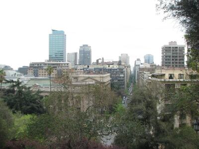
Santiago is wedged between the Andes and the coastal mountains range called cordillera. We visited in early October, which is the beginning of Spring here. While we had heard about the smog troubling Santiago (as in LA, the smog is worse in the winter), we had clear weather, and a big rain storm had washed the smog out of the air. <Larry: Santiago is at about the same latitude as Buenos Aires. One of the more impressive bits of civil engineering in Santiago is the main east-west freeway in the city, which runs in a tunnel lengthwise underneath the Mapocho River.>
The city is made up of 32 separate neighborhoods each of which has its own mayor and governance. The mayor of Santiago, a popularly elected sort-of “super mayor”, looks after the interests of the entire city through agreements that tax and distribute funds among the various neighborhoods of the city. As we wandered the city, we were impressed with the high-rise buildings which constitute most of the residential housing, the lovely greenery and trees along the streets, and the well-maintained, large parks. Even residential buildings tended to have park-like greenery around them rather than being built immediately abutting the next building and the sidewalk. Most of the buildings have balconies for added access to the lovely weather and greenery, and an aura of prosperity surrounds the city. Granted that we were in the more prosperous areas of the city, but we sensed through tours of other areas that the great economic inequality so often found in cities of Central and South America was not so evident here. We were both struck with the young age of the population and the lack of fat people.
The national drink is the Pisco sour, which is like a whisky sour but made with Pisco, a Chilean brandy, and egg white. The drink feels like a cool cloud that you don’t feel at all a first but then hits you fast and hard. The restaurants were excellent, particularly when dinner started with a Pisco sour.
Additional photos from Santiago can be found in our Photo Gallery and Moira’s Ship’s Store.
Punta Arenas, Chile
 From
Santiago we flew over the great Patagonian Ice Fields of Chile to Punta Arenas
on the discount airline of Chile, Sky Airlines. The airline was
competent, providing good service at half the price of LAN. Most Chileans
average about 5’5”, however, and this airline is not laid out for tall gringo
tourists. We suffered through the five-hour flight. This is a very long, thin
country. <Larry: That five-hour flight only took us about 2/3 of the length
of the country!>
From
Santiago we flew over the great Patagonian Ice Fields of Chile to Punta Arenas
on the discount airline of Chile, Sky Airlines. The airline was
competent, providing good service at half the price of LAN. Most Chileans
average about 5’5”, however, and this airline is not laid out for tall gringo
tourists. We suffered through the five-hour flight. This is a very long, thin
country. <Larry: That five-hour flight only took us about 2/3 of the length
of the country!>
<Larry: Punta Arenas is located on the northwest shore of the serpentine Strait of Magellan, where the settlement of “Magallanes” is indicated in the old chart at the left, and just across the Strait from the large island of Tierra del Fuego.> Punta Arenas was our point of departure for two trips: northwestward to Parque Torres del Paine, and southward on the Mare Australis cruise ship. We also stopped in Punta Arenas on our way back from El Calafate, Argentina to Santiago, Chile. Punta Arenas (population 150,000) is a jumping-off point for tourists wanting to explore Patagonia. The tourists, the Chilean military, and the king crab fishermen form a diverse community. We arrived in town on a Sunday, and the town felt deserted. Shops along the streets were covered with security shutters, and few residents roamed the streets, but wind and dust blew and blew. The temperature was moderate, about 40 degrees Fahrenheit.
Large colonies of penguins surround the city, but there are few other attractions in the immediate vicinity. There is an interesting naval museum which shows the very good PBS video on Shackleton’s adventure in the Antarctic. The city has some good restaurants and loads of shops selling all the winter clothes and trekking gear you might need. There is a North Face store here but their prices are way above the prices for comparable Chilean goods; I was surprised the store could survive. There are several pleasant plazas in the town with the usual cathedral, government buildings, and banks on all sides. <Larry: There were a few cruising sailboats anchored off the waterfront.>
 The most exotic food choice is the centolla
(king crab), which is only caught here and in Alaska. In Punta Arenas this
delicious crab is served in most all the restaurants in soups, crepes, lasagna,
and by itself. It is relatively affordable in comparison to Alaskan king crab.
The fishermen trap the crab in the rough, cold waters of the Strait of Magellan,
in waters up to 500 feet deep. Centolla is widely available in Chile,
but other than a few websites, we have not seen Chilean king crab for retail
sale elsewhere.
The most exotic food choice is the centolla
(king crab), which is only caught here and in Alaska. In Punta Arenas this
delicious crab is served in most all the restaurants in soups, crepes, lasagna,
and by itself. It is relatively affordable in comparison to Alaskan king crab.
The fishermen trap the crab in the rough, cold waters of the Strait of Magellan,
in waters up to 500 feet deep. Centolla is widely available in Chile,
but other than a few websites, we have not seen Chilean king crab for retail
sale elsewhere.
At times in South America we have found that locals hate to say they do not have something a visitor wants. In fact they will say anything to avoid the issue. We tried the supposedly best restaurant in town, located in the Hotel José Nogueira, a very pleasant restoration of an old mansion built in the 1890’s when this town flourished. The restaurant was in a sun room, part of the original mansion. It was lovely to see, but when we waited almost ten minutes for initial service we recognized that this restaurant lived on reputation, not service nor great food, as the dinner would show. I ordered salad and the king crab for which the restaurant is known. The salad arrived as did eventually Larry’s entrée, but nothing for me. We were willing to give the waiter some time but eventually we confronted him with the lack of my entree. The waiter finally and sadly admitted that there was no king crab that night. He just could not ‘fess up until we insisted on knowing the status of the entree. We told our Chilean guide this story the next day and he said it was not that unusual. He sadly agreed that the cause was this unwillingness to say ‘no.’ <Larry: Throughout Latin America, it is useful to ask “Is there any X?” (¿Hay X?) rather than “Do you have X?” (¿Tienes X?), which sometimes helps avoid this problem, by making the question impersonal. In fairness, the Shackleton Bar at the Hotel José Nogueira was first-class.>
On Monday morning, when we started our trip to Torres del Paine, the town had come alive with activity. Though many of the security shutters stayed down, small doors on the side provided access to the business within. The security shutters seem primarily to be a protection from the weather, especially the wind. A lot of commerce occurred behind these doors regardless of the weather. Punta Arenas looked to be prosperous but certainly not decorative or attractive. <Larry: I would have called the main street ‘tacky but charming.’>
The weather was harsh and fickle. In one morning we saw sunshine and rain, calm and harsh wind, and a drop in temperature of almost 20 degrees. <Larry: We were told that Chile is investing in a huge wind-generator “farm” to provide electricity in Patagonia. It’s certainly the region for it.>
The ozone hole is a significant fact of daily life here. There is a daily forecast of the UV level, and recommendations for hats, sunburn cream (above 40) and clothing covering the body. We both found sun glasses with polarized lenses and UV protection essential. I could feel the irritation to my eyes when I left my sun glasses off. Though the Montreal Protocol of 1987 has helped reduce the use of substances that deplete the ozone layer, it is forecast to take another 50-100 years to close the hole over Antarctica. <Larry: “Developing nations” are permitted to continue manufacturing and exporting R-12 (Freon) until 2010, and we have seen it widely available in Mexico.>
Torres del Paine
 Torres
del Paine (pronounced “PIE-nay”) is perhaps the finest national park in South
America. We chose to stay at Hosteria Las
Torres, a Chilean-owned and -operated hotel which, while not luxurious,
certainly was very pleasant. <Larry: Their staff was very responsive. One
evening the fire alarm in our room began to beep. A complaint to the front desk
brought the promise that someone would be there to fix it in five minutes. He
made it in three minutes.>
Torres
del Paine (pronounced “PIE-nay”) is perhaps the finest national park in South
America. We chose to stay at Hosteria Las
Torres, a Chilean-owned and -operated hotel which, while not luxurious,
certainly was very pleasant. <Larry: Their staff was very responsive. One
evening the fire alarm in our room began to beep. A complaint to the front desk
brought the promise that someone would be there to fix it in five minutes. He
made it in three minutes.>
Their guide and a driver met us at the Hotel Isla Rey Jorgé,
our hotel in Punta Arenas, for the five hour drive to the park. With this
arrangement we had the same experienced tour guide and naturalist, with his
driver, for the outdoor activities of the five days of our stay. All meals were
included, as were laundry, a well-done spa, horseback riding, and all the
trekking you could stand. The meals were competently served, al la carte for lunch, and buffet for
breakfast and dinner. Wine was included (though they had a  “premium” list for which there was
a charge).
“premium” list for which there was
a charge).
The park was our initial experience in the steppes of
Patagonia. The centerpiece of the park is the spectacular Torres (towers)
del Paine mountains, jutting up 2500 meters from the steppes. These are
geological formations of granite, breathtaking and awesome. These towers and
the volcanic ‘horns’ adjacent are not part of the Andes, but rather separate
geological features formed  millions
of years ago as the Andes formed. At this end of the continent, the Andes do
not have the sheer height of Ecuador and Peru. Here they are near their end,
and rarely climb above 2500 meters in height before they disappear into the
Atlantic Ocean, to reappear in Antarctica. But the combination of the steppe
and the mountains, with the emerald green of the beautiful glacial lakes is
most striking. This is the most beautiful area of the world I
millions
of years ago as the Andes formed. At this end of the continent, the Andes do
not have the sheer height of Ecuador and Peru. Here they are near their end,
and rarely climb above 2500 meters in height before they disappear into the
Atlantic Ocean, to reappear in Antarctica. But the combination of the steppe
and the mountains, with the emerald green of the beautiful glacial lakes is
most striking. This is the most beautiful area of the world I  have
seen in our tours. While Wyoming and Montana provide some of this spectacular
scenery, I must admit that the beautiful mountain and high steppe country of
Torres del Paine heads my list.
have
seen in our tours. While Wyoming and Montana provide some of this spectacular
scenery, I must admit that the beautiful mountain and high steppe country of
Torres del Paine heads my list.
We came for the scenery and to understand glaciers. Our guide was interested in our trekking experience so we did several walks with him, mostly chosen from the easier hikes of several hours. Larry wanted to try a 12 kilometer hike on the last day, but I decided that I would try a horseback trip instead. Both of us were pleased with our choices. Larry returned feeling the wear and tear of the last 6 kilometers of his hike, and I was pleased that I could (just barely) stay on a horse as it traipsed up and down the steep hills around the Hosteria.
There are opportunities for longer treks, especially the
famous “Circuit” and “The W” trek both of which take the hiker around the horns
of the Paine and the  beautiful
lakes. Chile has seen that hikers are provided with simple amenities on the
trail in the form of shelters, places to camp, and good trails which are well
maintained, but all supplies have to be packed in and out by the trekkers and
their guides.
beautiful
lakes. Chile has seen that hikers are provided with simple amenities on the
trail in the form of shelters, places to camp, and good trails which are well
maintained, but all supplies have to be packed in and out by the trekkers and
their guides.
<Larry: One daily amusement was provided as we were driven out of or into the hotel property (an area of private property within the park boundary) to or from whatever venue we would be exploring that day. The road crossed a stream via a narrow bridge, built in the early 1900’s to accommodate horse-drawn carriages. The van cleared the sides of the bridge with inches to spare, and the outside rear-view mirrors had to be folded in to clear the opening. The roads in the park were unpaved but in generally excellent condition.>
Glaciers, Lago Grey
The last ice age ended about 11,000 years ago, leaving the earth with ten percent of its land area covered with glaciers, some of which now cover stretches of Patagonia and Antarctica.
 <Larry:
Glaciers are formed by thick masses of snow turned into ice through the
compression of their own weight. The ice then moves downhill with gravity. One
of our guides defined a glacier as “a mass of ice in motion over land.” A
glacier is a study in dynamic equilibrium. In Patagonia there is usually (not
always) a lake or an ocean fjord at the face (bottom) of a glacier. Ice at the
face of a glacier breaks off into the water to form icebergs. The glacier
slides downhill into the space vacated by the icebergs, propelled by its own
weight, its mass replenished from snows high above, its speed of travel
regulated by the rate at which snow falls to replace the ice and by the
friction of the ice with the surface it travels over. If the speed with which
icebergs break off is balanced by the speed with which the glacier moves
forward, the glacier is said to be “stable.” Otherwise, it is “advancing” or
“retreating.” Glaciers advance and retreat in a cycle with a period of about
100,000 years, driven by the cyclical changes in the Earth’s climate.
Throughout Patagonia, some glaciers are advancing, others retreating, and
others are stable.>
<Larry:
Glaciers are formed by thick masses of snow turned into ice through the
compression of their own weight. The ice then moves downhill with gravity. One
of our guides defined a glacier as “a mass of ice in motion over land.” A
glacier is a study in dynamic equilibrium. In Patagonia there is usually (not
always) a lake or an ocean fjord at the face (bottom) of a glacier. Ice at the
face of a glacier breaks off into the water to form icebergs. The glacier
slides downhill into the space vacated by the icebergs, propelled by its own
weight, its mass replenished from snows high above, its speed of travel
regulated by the rate at which snow falls to replace the ice and by the
friction of the ice with the surface it travels over. If the speed with which
icebergs break off is balanced by the speed with which the glacier moves
forward, the glacier is said to be “stable.” Otherwise, it is “advancing” or
“retreating.” Glaciers advance and retreat in a cycle with a period of about
100,000 years, driven by the cyclical changes in the Earth’s climate.
Throughout Patagonia, some glaciers are advancing, others retreating, and
others are stable.>
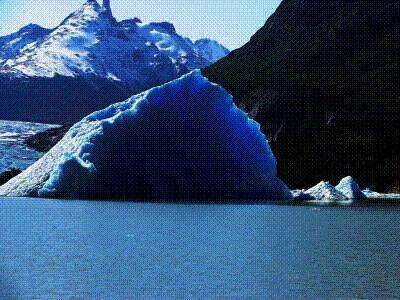
<Larry: When a glacier begins to retreat, it leaves behind at its point of furthest advance a wide hill of the rock it pushed before it, called a “terminal moraine.” This moraine often becomes a dam, and a lake of glacial melt-water forms in the space between the moraine and the glacier.> This is what we saw on Lake Grey. As the glaciers “calve” or break off icebergs that move with the winds to the moraine, in an area locally called the “graveyard of icebergs.” The icebergs take months or years to melt but the calving continues, keeping the graveyard full.
Guides in multiple parks consistently told us that the
expanding and shrinking of the glaciers is a natural phenomenon, seen often in
the geological record. <Larry: we are in a warming cycle of the Earth’s
climate that began millennia past.> The concern is the  uncertainty
about whether the rate of shrinking in many glaciers is abnormal. Melting of
floating ice will not affect ocean heights or shorelines around the world.
However, the melting of the glaciers on a land mass such as Antarctica could
have very serious consequences for shoreline cities, in addition to any other
climatic changes that may occur.
uncertainty
about whether the rate of shrinking in many glaciers is abnormal. Melting of
floating ice will not affect ocean heights or shorelines around the world.
However, the melting of the glaciers on a land mass such as Antarctica could
have very serious consequences for shoreline cities, in addition to any other
climatic changes that may occur.
The deep blue of icebergs is a result of light refraction through the ice. The blue color is seen by the eye because other colors have been absorbed. The more dense the ice, the deeper the blue <Larry: so the bluest ice comes from the bottom layer of the glacier. As the glaciers grind their way down a mountain, the ice creates and picks up a kind of finely-pulverized rock “flour.”> Where glaciers calve into lakes, the process liberates the rock “flour,” causing a milky grayish mixture in the water called “glacier milk.” Glacial lakes have a characteristic milky gray-blue color.
At Torres del Paine we saw storms, huge clouds, rapid changes in temperature and beautiful bright skies. We were very fortunate to see the Torres del Paine against a clear sky. None of the Horns hid from us, but rather showed themselves with all the grandeur one could dream of. We were able to see the beautiful condor, the national bird of Chile, as well as the guanaco, a smaller version of the Peruvian llama. Wild flowers were beginning to come out, beautiful to see and Larry enjoyed taking their picture. <Larry: Tradeoffs, right? We avoided the winds that are strong enough to “knock people down,” which we were assured happen in the summer. We the avoided biting cold of winter. But as pretty as the buds were, it was painful to miss by a couple of weeks the flowers in full boom. The low-scrub flora here reminded me of Las Cajas in Ecuador, but Las Torres are not much above sea level, where Las Cajas is at 14,000 feet.>
After five days in Parque Torres del Paine, our guide and driver transported us back to Punta Arenas for an overnight stay at Hotel Isla Rey Jorgé. The next morning we produced our documents and checked our luggage with the office of Mare Australis, the cruise ship which would take us to Cape Horn.
Additional photos from Torres del Paine can be found in our Photo Gallery and Moira’s Ship’s Store.
The Mechanisms of Travel
We typically make our airline reservations on ForestDirect.com. They have served us well because they look after their customers. It is not unusual for an airline to cancel a flight without notice. Forest Direct several times has warned us of a cancellation, and helped us rebook on an alternate flight, saving us money and much stress. Without Forest Direct we wouldn’t have heard about the cancellation until we arrived at the airport, and would have been in a difficult position to make a new reservation without paying more money, let alone salvaging any connections. We have gotten to know one of the vice presidents of the company well.
Our experience with airlines in Central and South America has generally been excellent. The airports are modern, usually fairly new, with amenities equal to and in many cases ahead of the USA. The planes are well-maintained, often new, and the airlines still serve meals with wine at no cost to the traveler. Our favorite airline is LAN, the national airline of Chile. The best-dressed stewardesses are with Avianca, the national airline of Colombia: they wear bright red uniforms with short, red capes, little red bowler hats, and long black hair (provided free by nature); they are recognizable throughout the airports of Central and South America.
We also use the Internet to make hotel and tour reservations. Most of the hotels and B&B's we seek out, even the smaller ones, now have Web-based reservation services. We try to stay at places that also provide Internet access to their guests. Most do, though the policies of payment, strength of signal, and bandwidth vary widely. In the smaller lodges, Internet access is usually free. The smaller lodges also provide more contact with residents of the country, enhancing our traveling experiences, and Larry’s Spanish comes in very handy. Once touring begins in this area of the world, one is at a great disadvantage if one has no Spanish. We frequently have to call on the telephone to make restaurant reservations or provide credit card information, and Spanish <Larry: and Skype!> is very helpful. Typically, I will call with my Spanish phrases carefully practiced. Once in conversation the Spanish party is worn down by my Spanish and either answers in English or passes the call to an English speaker. But about half the time, no one there speaks English. Many a conversation and reservation has been rescued by putting Larry on the phone.
For this trip I bought travel insurance, which I usually do not do. But this trip was long, potentially dangerous, with hard travel, and had a number of intricately connected pieces that had to line up. If one leg of the trip did not come off well, the others segments might have broken down. In addition, the policy we bought had a $250,000 medical evacuation policy. While we have a good medical evacuation policy with the diving group DAN, I felt the extra insurance was important. We were much more likely to break a hip or a skull wandering around frozen Patagonia than in Cartagena. The medical evacuation would have gotten us back to the States quickly with medical assistance surrounding us. The insurance was fairly cheap <Larry: about 3% of the total cost of the trip> for the benefits provided. Its important to keep in mind when traveling as we do that though medical care is good in most parts of the world (near any major city) in the back country it is hard to come by, and—if care is available—one must have cash to secure good care. Your medical insurance card will not work here!
<Larry: You know you’re outside the US “primary sphere of influence” when the electricity is 220 Volts! Your appliances won’t work here, either, without at least a special plug, and maybe a voltage converter.>
![]() Rate this page
(SouthAmerica7.htm)
Rate this page
(SouthAmerica7.htm)