The Log of Moira
Western Caribbean: Belize (December 2009 - February 2010)
These are mostly Susan’s remarks. Larry’s notes are indicated thus <Larry: blah blah blah.>.
Mangroves
Whenever I hear about Belize I think mangroves, mangroves, mangroves! Belize advertises itself with pictures of South Pacific-like cays (sometimes spelled cayes, but always pronounced “keys”) covered with white sand and palm trees with crystal-clear waters. I have no arguments with claims of clear water--it is often clear, clean and beautiful. But let me share with you that the palm-covered, sandy cays are few and far between. The few that do exist tend to be small and remade by man to be sandy and palm-covered. The vast majority of the palm trees we saw were planted. The mangroves are protectors of the cays and the vanguard against heavy winds and waves often found in Belize with tropical storms or hurricanes. When the mangroves are cut down and replaced with the more “tropical” palm trees, nature’s protection is removed, and the islands are vulnerable to wave damage in storms. <Larry: Belize has more than a few islands that have been cut in half by storm action, including Cay Caulker. The cuts appear to have occurred at spots where the mangroves had been cut down. As a result, where you find palm trees, you tend to find sea walls in varying states of disrepair, and vice versa.>
We grew fond of the mangroves, for with the mangroves comes a thick, heavy mud sea floor which is a gift to the cruiser. Anchoring in thick mud is a pleasure…you just do not move. Coral bottoms are a slippery surface across which an anchor will slide. <Larry: The comparison is not original: getting your anchor to set on a coral hardpan bottom is like anchoring on an asphalt parking lot. More than once we went to pick up the anchor after a real blow, and looking down through the clear water were horrified to see the anchor lying on the surface of the coral bottom, not dug in at all! Of course, it is easier to like anchoring in heavy mud if one has a washdown hose on the foredeck, for washing the mud off the anchor and chain as they are retrieved. Mangroves and coral are antithetical. Coral requires clear water to grow, whereas mangroves trap silt and mud, releasing it into the water when hit by wave action. So, if coral is present, it will usually be found on the up-current (usually East or South) side of an island, while mangroves will be found on the down-current (usually West or North) side.>
Punta Gorda
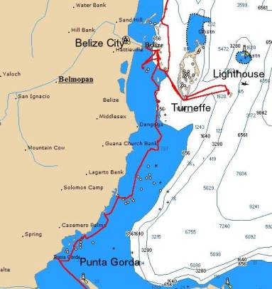 We started our adventure in Punta Gorda, the
southernmost major town in Belize and a port of entry. The “port of entry” is
important for cruisers because, just like any other traveler to a new country,
we too must check in with Immigration and Customs, but also with the Port
Captain, and sometimes other officials such as Agriculture and Health.
<Larry: One cannot enter a country at any old port that takes one’s
fancy—one’s first contact with land must be at a port of entry.> In Punta
Gorda, we anchored off of the immigration dock in about 20 feet of not really
clear water. The bottom was mud, so at one time the cleared area of the town
was filled with mangroves. We launched our hard dinghy
(our “station wagon,” but only 8 feet long) from the foredeck of the boat, not
bothering to mount the outboard engine because we were less than a quarter of a
mile from the dock. We had noticed a group of people standing on the dock, and
as we got closer, we realized they were the various port officials, waiting for
us, and looking at our dink with some apprehension. Normally they see
inflatable dinks with a fast engine in the 8 to 15 horsepower range. Customs
and other officials often inspect the boat, and often hitch a ride with the
boat’s captain to do so. I think that they like the ride to the boat and want
to look around these boats that come to Belize from all over the world. I would
if I were they. This time we heard no requests to go inspect Moira!
During our check-in, which was professional and quick, the Port Captain’s
representative, a young man, told us that no one in Customs wanted to see our
boat because they did not like the idea of being rowed out to Moira in
our small dink. <g>
We started our adventure in Punta Gorda, the
southernmost major town in Belize and a port of entry. The “port of entry” is
important for cruisers because, just like any other traveler to a new country,
we too must check in with Immigration and Customs, but also with the Port
Captain, and sometimes other officials such as Agriculture and Health.
<Larry: One cannot enter a country at any old port that takes one’s
fancy—one’s first contact with land must be at a port of entry.> In Punta
Gorda, we anchored off of the immigration dock in about 20 feet of not really
clear water. The bottom was mud, so at one time the cleared area of the town
was filled with mangroves. We launched our hard dinghy
(our “station wagon,” but only 8 feet long) from the foredeck of the boat, not
bothering to mount the outboard engine because we were less than a quarter of a
mile from the dock. We had noticed a group of people standing on the dock, and
as we got closer, we realized they were the various port officials, waiting for
us, and looking at our dink with some apprehension. Normally they see
inflatable dinks with a fast engine in the 8 to 15 horsepower range. Customs
and other officials often inspect the boat, and often hitch a ride with the
boat’s captain to do so. I think that they like the ride to the boat and want
to look around these boats that come to Belize from all over the world. I would
if I were they. This time we heard no requests to go inspect Moira!
During our check-in, which was professional and quick, the Port Captain’s
representative, a young man, told us that no one in Customs wanted to see our
boat because they did not like the idea of being rowed out to Moira in
our small dink. <g>
After we finished with the officials, we strolled across the street to complete the second ritual associated with entering a new country: we got ourselves a SIM chip for our GSM cell phone. In each country to visit, we generally need to replace the SIM chip to assure cell phone communication. We have our Skype account set up with call forwarding, so that our friends can call us on a US phone number, and the inbound calls ring on our cell phone wherever on the planet we may be, so long as the cell phone has the SIM chip of the country in which we are cruising. <Larry: Our friends pay only for the call to our US number, and we pay for the local call from the Skype point-of-presence to our cell phone. A SIM chip carries the key that provides access to telephone services of your account with a particular carrier. They are seldom transferable between countries. Belize has a telephone monopoly (not in law, but in practice), the history of which reads like something out of Gilbert and Sullivan. BTL, the telephone company, takes a number of anti-competitive actions like blocking outbound Skype calls. Knowing about this situation in advance, we took the precaution of investing in some VPN software from Witopia, which ensured that outbound Skype calls from our laptop worked fine for us.> We also have a satellite phone through which we can receive and send email as well as receive very necessary weather forecasts.
Belize, officially English-speaking, but practically multi-lingual with Spanish and Creole just as prevalent, has the highest per capita income in Central America. That income does not show itself until you visit in San Pedro, the northernmost Caribbean-facing port of entry and the tourist capital of Belize (see below). It was strange to approach people and hear English. We were so used to Spanish that English sounded strange and out of place. Belize was an English colonial province until the mid-1900’s. Now it is an independent, democratically-governed country, still a part of the British Commonwealth. Belize’s money, coins and bills, has Queen Elizabeth’s picture on it.
What we saw of Punta Gorda was bustling with people shopping, working and attending school but it did not look like much physically. Sort of worn out and dreary, though the immigration building was new as were the banks and the Belize telephone monopoly, BTL. We saw only a small corner of the town as we were eager to get to the cays of Belize before nightfall.
The Cay(e)s
 We spent most of our time sailing among the offshore
cays of Belize, behind the longest barrier reef in the Americas. The sailing is
very pleasant because there is very little wave action under normal conditions.
The barrier reef of coral protects the coast and the cays from wave action but
not from wind. When the trade winds are blowing strong or “hooting” as we say,
cruisers in Belize feel the wind but with the low wave heights, the effect is
much reduced. The mangroves in some anchorages do take the sting out of the
trade winds at deck-level when they are blowing 20 to 30 knots.
We spent most of our time sailing among the offshore
cays of Belize, behind the longest barrier reef in the Americas. The sailing is
very pleasant because there is very little wave action under normal conditions.
The barrier reef of coral protects the coast and the cays from wave action but
not from wind. When the trade winds are blowing strong or “hooting” as we say,
cruisers in Belize feel the wind but with the low wave heights, the effect is
much reduced. The mangroves in some anchorages do take the sting out of the
trade winds at deck-level when they are blowing 20 to 30 knots.
For our first night we
headed to the Mangrove Cays, a group of twenty or so small cays with several
areas in which to anchor. We usually navigate electronically, but in Belize
where coral can pierce the surface or lurk just below the surface, a bow watch
man, or Susan in this case, was of critical importance. I was anxious in this
role because I was unsure if I would be able to see danger in time to change
the course of the boat. However, with rare exceptions, the dangers in the Belize
cays are usually easy to see. The key indicators of danger are colors. The
color of the water with sun light behind you (about 11am to 3pm if eastbound,
early to about 1pm if westbound) is instructive. Deep blue water is safe. Brown
waters are steered around and usually full of coral formations. However, not
all dark-colored areas are coral; grassy areas are greenish-brown, while coral
areas are reddish-brown—the trick is to tell the difference in time. Grassy
areas are usually safe whereas coral areas shallow enough to show their
brown colors are not. Crystal-clear waters  are
often sandy bottoms but depths can be difficult to gauge. It is also hard to
tell if one is in deep water or fairly shallow water. So, the captain needs a
good depth sounder and pays attention to that machine. From the bow of the boat
and on top of the dinghy I grew accustomed to seeing the path to our next
anchorage or the way into an anchorage by watching the changing colors of the
water. Usually, I could see the path in deep blue water and Larry could use the
depth sounder to determine the best spot to anchor. Because mangroves were our
usual companion on these cays, the water was clean enough to spot most shoals.
After several days in Belize we regained confidence in the skills we gained
while sailing in the waters of Panama, which are also full of coral heads just
where you don’t want them. <Larry: A depth sounder is only useful to tell
how deep the water is for anchoring purposes, or for confirming one’s suspicion
that one has already run aground. For the first few days, we adhered rigidly to
the dotted lines (recommended courses) in the cruising guide. After a while, we
developed a slogan: “No dotted lines, no anchor signs,” and worked at becoming
more flexible.>
are
often sandy bottoms but depths can be difficult to gauge. It is also hard to
tell if one is in deep water or fairly shallow water. So, the captain needs a
good depth sounder and pays attention to that machine. From the bow of the boat
and on top of the dinghy I grew accustomed to seeing the path to our next
anchorage or the way into an anchorage by watching the changing colors of the
water. Usually, I could see the path in deep blue water and Larry could use the
depth sounder to determine the best spot to anchor. Because mangroves were our
usual companion on these cays, the water was clean enough to spot most shoals.
After several days in Belize we regained confidence in the skills we gained
while sailing in the waters of Panama, which are also full of coral heads just
where you don’t want them. <Larry: A depth sounder is only useful to tell
how deep the water is for anchoring purposes, or for confirming one’s suspicion
that one has already run aground. For the first few days, we adhered rigidly to
the dotted lines (recommended courses) in the cruising guide. After a while, we
developed a slogan: “No dotted lines, no anchor signs,” and worked at becoming
more flexible.>
After two nights at Mangrove Cays,
and a night at Bedford Cay, we cruised to New Haven Bight, a natural harbor
surrounded by mangroves on three sides. Nothing appeared to be inhabited on the
land. We did not go ashore, having been warned about the “no-see-ums” or tiny
black bugs that bite voraciously. New Haven Bight was pristine and lovely even
without the Chamber-of-Commerce prescribed palm trees. <Larry: For some
reason, Belize had the most beautiful sunrises and sunsets we’ve seen on our
travels. There are photos of our favorites in the Gallery and Moira’s Ship’s
Store.> The quiet was broken only by the sound of the a few frigate birds
whooshing around (most of  the
cays had surprisingly little bird life). But we did see our first sign of real
estate activity, a sign on the shore by Century 21 of acreage for sale. It was
hard to imagine anyone being interested—the acreage offered was apparently an
old fishing camp long since abandoned. From New Haven we sailed to Placencia, a
town about midway up the coast of Belize and a cruiser’s delight.
the
cays had surprisingly little bird life). But we did see our first sign of real
estate activity, a sign on the shore by Century 21 of acreage for sale. It was
hard to imagine anyone being interested—the acreage offered was apparently an
old fishing camp long since abandoned. From New Haven we sailed to Placencia, a
town about midway up the coast of Belize and a cruiser’s delight.
<Larry: One of the charming elements to the experience of Belize was the encounters with the Belizean sail-powered fishing craft. Belize may be one of the last places in the Western Hemisphere with a fleet of working sail. In some cases these craft carry half-a-dozen skiffs that do the actual fishing. While in many cases they actually get from place to place under outboard power, we can confirm from personal experience that they do sail.>
Northers (Cold Fronts)
It was at Placencia that we experienced our first “norther” or cold front outside of the shelter that the Río Dulce provided in Guatemala. These northers are the blasts of cold air blowing down from the central plains of the United States. Cold fronts, mostly from November to March, affect the weather patterns of the Yucatán peninsula and further south, occasionally reaching Panamá. The fronts shift the winds from trade-wind Northeast to Southeast and the winds go light, then quickly on around the clock to Northwest where it may blow hard for a day or two before returning to Northeast. The air temperature at the beginning of the cycle begins with warm, humid air as the wind goes very light for a day or so <Larry: a “calm before the storm”>, then just before the front arrives comes cooler air, down to the mid 60’s. The average norther brings 20-25 knots of wind sometimes with cloudy skies and squalls of heavy rain. <Larry: Just after we left Belize, a norther came through with winds reported of over 50 knots.> The northers usually come about once or twice a week, though the interval is seasonal, and we were treated to two or three a week in the period we were there.
They do often provide a helping hand to the sailor who wants to go North or East, by providing a window of opportunity to dash in a direction usually difficult to travel in trade-wind conditions. When you want to go North as we were, sailing into Northeast winds of any velocity is not fun, more like being in a washing machine than a sail boat in the tropics. With the right wind, like South or Southeast if there is little swell with it, sailing North or Northeast can actually be pleasant. “Pleasant” is important to me and even Larry now looks for the best winds to satisfy his wife, who is not pleased with boisterous conditions. So we watched the weather forecast carefully and then moved when the winds seem right. It’s not a science, but rather an art to try to determine if the winds at sea will be with you or against you. <Larry: When we arrived in Mexico, a marina manager who had been in the area full-time for 11 years said that the last few months had brought the worst sustained sailing weather he had seen in his entire time there.>
During our time at Drowned Cays and Robinson Cays (both close to Belize City) we learned how important it was to seek good anchorages based on the protection the offer from predicted winds. One time we visited the Robinson Cays, a group of cays south east of Belize City, where a great deal of aquaculture was going on, the process of growing fish in a confined area for commercial purposes, a new and growing industry here. Unassociated with the aquaculture was a fish camp on the shore near where we anchored. During the day the dozen or so men fished returning in the evening to filet the fish in preparation for sale. We wandered over one afternoon in our dinghy asking if we could buy fish. They said no, but they would be glad to give us some. How much did we want? We ended up paying a small amount and providing about a gallon of Coca-Cola to them for some very good red snapper. During our stay a front was predicted with winds in the range of 20 knots. We were well anchored. Our position in the cay was well protected against any wind except Northwest. During that night we were glad to have heavy anchor gear and strong chain, as the winds were stronger than we expected. Our anchor held, but we spent most of night talking to each other and hoping our anchor chain was as strong as we thought it was. In the morning we took off back to the Drowned Cays. With a front comes cool air which at this time of year brings the temperature into the high 60’s and mid 70’s. With this refreshing coolness, the bugs disappeared.
Placencia
We arrived in Placencia harbor,
really a bight surround by the town on the North, the mainland to the West, and
a narrow island that was under development to the East. Development moves very
slowly here because the population is small and the demand for high-end housing
or high-end buildings of any kind is very small. By the time we arrived in
Placencia the wind was blowing about 20 knots and by nightfall the norther had
arrived with winds of 25 knots and overcast sky. We were well anchored in
Placencia’s sandy bottom so the winds of 25 knots did not bother us. Frequently
we were able to have dinner in our cockpit, or the “terrace” to me, even during
a norther. We have a dodger and bimini as well as cockpit screens which help to
deflect the winds. But when a norther is blowing, you do not want to be at sea
or trying to get into an unfamiliar anchorage where coral threatens boats not
under careful control. It’s the wind and the coral that make Belize a demanding
cruising ground. It’s like any new cruising ground…it takes several days to
feel comfortable. <Larry: When we went into town the first day, we saw a
number of buildings at odd angles, other buildings with badly buckled concrete
floors, and docks at cockeyed angles. Placencia had been severely damaged
several months  before
by an earthquake in Honduras.>
before
by an earthquake in Honduras.>
It is also important avoid overconfidence. <Larry: Every new cruising ground has its lessons to teach. The trick is to stay lucky long enough to get proficient. Just because you “know a thing or two” don’t mean you know it all.> Belize is very protective of its reefs. In certain more protected marine preserves, a daily charge is collected by the department of fisheries and a half-hearted patrol is undertaken. But if you go onto a reef or damage coral by hitting it with your boat, Belize has been known to fine the cruiser significantly and seize the boat until the fine is paid.
Placencia is a town of 800 residents with capacity to house at least the same number of tourists. Lodging was available in homes of residents, in simple B&B’s, and in very luxurious lodging such as Francis Ford Coppola’s Turtle Inn. We went there one evening to try the restaurant in celebration of our 39th anniversary. The restaurant had a good reputation, but as soon as the waiter eagerly told us that tonight was their famous “Pizza night” I feared that we were in trouble. Actually, we ended up having a very good dinner, though not pizza. However, we would not have called it gourmet food.
 Placencia
is small and colorful with many houses on stilts, a common Caribbean
architecture that lifts the house up above the ground to catch the breeze. The
community proudly talks about their concrete sidewalk, one mile long by the
beach and adjacent to many small businesses such as John the Baker and his
competition, the Swiss Baker. The fishing cooperative was also close by, though
we were seldom able to get fish from them. The first afternoon we visited we
did manage to buy red snapper from the cooperative, but only I think because
the manager of the cooperative had bought it from one of the fishermen for his
own use and figured he could sell it to us for a profit. One time we were able
to buy frozen lobster tails which were delicious but the cooperative did not
normally have fish to sell when we visited. We found this curious and of course
unfortunate for us as we had been talking about all the delicious fish we would
have in Belize, especially the lobster, which was in season. We suspect that
the cooperative, when it gets fish, is obligated to sell it to an exporter and
only sells to the public when that quota is met. We were told by the Swiss
Baker to buy fish directly from the fishermen as they come into the harbor at
dusk. But during our stay we did not find those fishermen. Placencia did have
five small grocery stores which made provisioning easy. There was also an
entrepreneurial grocer from the town of St. Ignatius, in the interior of
Belize. He bought vegetables, fruits and meats, such as pork and chicken, from
the farmers in St. Ignatius and trucked them to Placencia (and several other
small towns) each morning. He had a good variety of wares, with fresh cilantro,
eggs, and even sour cream some days, and if you desired something special he
could usually produce it several days hence.
Placencia
is small and colorful with many houses on stilts, a common Caribbean
architecture that lifts the house up above the ground to catch the breeze. The
community proudly talks about their concrete sidewalk, one mile long by the
beach and adjacent to many small businesses such as John the Baker and his
competition, the Swiss Baker. The fishing cooperative was also close by, though
we were seldom able to get fish from them. The first afternoon we visited we
did manage to buy red snapper from the cooperative, but only I think because
the manager of the cooperative had bought it from one of the fishermen for his
own use and figured he could sell it to us for a profit. One time we were able
to buy frozen lobster tails which were delicious but the cooperative did not
normally have fish to sell when we visited. We found this curious and of course
unfortunate for us as we had been talking about all the delicious fish we would
have in Belize, especially the lobster, which was in season. We suspect that
the cooperative, when it gets fish, is obligated to sell it to an exporter and
only sells to the public when that quota is met. We were told by the Swiss
Baker to buy fish directly from the fishermen as they come into the harbor at
dusk. But during our stay we did not find those fishermen. Placencia did have
five small grocery stores which made provisioning easy. There was also an
entrepreneurial grocer from the town of St. Ignatius, in the interior of
Belize. He bought vegetables, fruits and meats, such as pork and chicken, from
the farmers in St. Ignatius and trucked them to Placencia (and several other
small towns) each morning. He had a good variety of wares, with fresh cilantro,
eggs, and even sour cream some days, and if you desired something special he
could usually produce it several days hence.
Placencia also hosts an agency of the Moorings, a sail boat charter agency catering to the bareboat cruising crowd. Their customers come to Belize for seven days, and try to sail at least five of those days <Larry: norther or no norther!>. The difficulty these renters cause is that their anchoring skills sometimes do not live up to the demands of this windy, coral-infested patch of the Caribbean. In Placencia, the evening’s entertainment was often supplied by watching a Moorings boat drag across the harbor, sometimes repeatedly. This was particularly unsettling during a norther, when re-anchoring would be difficult even for an experienced crew. We grew to believe that either the anchoring equipment on the Moorings boats was not sufficient or else the level of proficiency demanded by the agency was not adequate. We tried to stay upwind of them. It was pretty scary to watch a big catamaran with the sail cover bearing the Moorings logo dragging toward you, with several people on deck yelling and waving at each other.
<Larry: While we were at Placencia, we saw a boat called Latitude Adjustment, and crossed paths with her in several other anchorages over the next several weeks. The only thing remarkable about her was that her anchor rode was nylon line, rather than chain. In these waters, the abrasive characteristics of coral make nylon inadvisable. In addition, a boat anchored with chain tends to sit fairly placidly as the wind gusts, while a boat anchored with nylon tends to sheer from side to side over a considerable distance. Nearly everyone anchors with only chain. Certainly we were glad to have anchored at some distance from Latitude Adjustment, as she danced over a wide area. We saw her again at the anchorage in Blue Ground Range. Some weeks later we read a news report that her skipper was in fact a fugitive American, wanted in the US on weapons and fraud charges, who later pled guilty in Belize to charges of money laundering.>
Mr. Fix-It - I
 Maintenance
and repair on the boat takes about 20 hours each week. Minding the boat’s
systems and repairing them is mostly Larry’s domain, but we both look for chafe
and general distress in need of TLC. We pulled out from Placencia heading for
the small Lark Cay Range only four or five miles away when our radar unit on
deck went blank. Being overly cautious, I voted to turn back to Placencia,
whence we could send the unit back to the manufacturer to be fixed. Larry was
correct that there was no real assistance available in Placencia and probably
not in Belize, but he agreed to return, muttering under his breath! We have
duplicate radar units, one on deck and one at the navigation station. So we
could have continued to find our way electronically from the navigation
station. When we returned to anchor Larry got busy on the one repair option
under his control. The most common malady for electronic boat systems, by far,
has been bad electrical connections. Corrosion is a part of the sailor’s life
and we need to constantly combat that, particularly in electrical connections.
Larry took the radar unit apart <Larry: carefully ignoring the notices like
NO USER SERVICABLE PARTS INSIDE> and found a loose connection. After
cleaning the electrical connection and putting everything back together the
system worked. Wonderful! Much better than flying to Miami to submit the unit
to the manufacturer’s tender mercies! So we picked up the anchor again the same
afternoon and off we went to Lark Cay Range, another mostly-uninhabited
mangrove anchorage.
Maintenance
and repair on the boat takes about 20 hours each week. Minding the boat’s
systems and repairing them is mostly Larry’s domain, but we both look for chafe
and general distress in need of TLC. We pulled out from Placencia heading for
the small Lark Cay Range only four or five miles away when our radar unit on
deck went blank. Being overly cautious, I voted to turn back to Placencia,
whence we could send the unit back to the manufacturer to be fixed. Larry was
correct that there was no real assistance available in Placencia and probably
not in Belize, but he agreed to return, muttering under his breath! We have
duplicate radar units, one on deck and one at the navigation station. So we
could have continued to find our way electronically from the navigation
station. When we returned to anchor Larry got busy on the one repair option
under his control. The most common malady for electronic boat systems, by far,
has been bad electrical connections. Corrosion is a part of the sailor’s life
and we need to constantly combat that, particularly in electrical connections.
Larry took the radar unit apart <Larry: carefully ignoring the notices like
NO USER SERVICABLE PARTS INSIDE> and found a loose connection. After
cleaning the electrical connection and putting everything back together the
system worked. Wonderful! Much better than flying to Miami to submit the unit
to the manufacturer’s tender mercies! So we picked up the anchor again the same
afternoon and off we went to Lark Cay Range, another mostly-uninhabited
mangrove anchorage.
Belize City
Belize City is home to about 70,000 people, about one-third of Belize’s population. It was a hive of activity and commerce but not a good spot to anchor because it is an open roadstead, open to the prevailing East winds, without any protection from any winds except northwest. It lacks mangroves, palm trees, and white beaches. It does have a Radisson with a dock area that welcomes dinghy’s from cruisers who anchor off the dock and come ashore for provisioning or to do official paperwork. Interestingly, cruise lines frequent Belize City, delivering over 700,000 visitors a year. The big cruise ships use Belize City because it has a deep, well-marked channel and adequate depth close to shore where they can anchor to pick up or discharge passengers.
<Larry: Cruisers who want to visit Belize City often anchor at Drowned Cays, just a few hours away, and wait for a day of light winds to make a quick daylight visit to Belize City. We were fortunate to get very mild conditions for our first visit to Belize City, and anchored overnight in front of the Radisson.> Off of Belize City we anchored in 12 feet and took our dinghy ashore.
Once ashore we hired a taxi cab with Luis Ramon, our guide for the next four hours. Without Luis, we would not have found out about the breadth of supplies that are available in Belize City, if you know where to look, and we would have missed hearing about his eight kids! These were fascinating stories, and the provisioning helped us greatly. Luis had two kids still at home but his other six kids were relatively settled, mostly in Belize. When Luis honked at someone it was either a daughter, son, or an in-law to one of the kids. He talked to and knew many people on the streets and driving around. His kids had gone though high school with several having done some university work. One daughter, a nurse, lived inland in Belize, and he talked about her with a great deal of pride.
After dropping off several weeks’
accumulation of dirty clothes at a small laundry, our first stop with Luis was
Immigration. Every thirty days a cruiser is required in Belize to renew his
visa or tourist card, and it was time to get this done. <Larry: Likewise,
the boat’s cruising permit needs to be renewed every thirty days.  Unfortunately,
the cruising permit was not recognizably labeled as such, and we didn’t realize
that that was what it was, nor that we had to renew it. Oops. That earned us a
scolding when we checked out of the country, though that was preferable to the
fine we would have received if the Belizean Coast Guard had gotten to us
first.>
Unfortunately,
the cruising permit was not recognizably labeled as such, and we didn’t realize
that that was what it was, nor that we had to renew it. Oops. That earned us a
scolding when we checked out of the country, though that was preferable to the
fine we would have received if the Belizean Coast Guard had gotten to us
first.>
We also had heard of a respected marine store, Duke Marine, where we wanted to try our luck at finding various replacement parts. Luis took us there as well as to several automotive shops, which we combed over in an attempt to find needed parts and assorted supplies for the boat.
Belize City has a very good grocery store, Brodie’s. It was fun to go in look around at the depth of the inventory. Brodie’s was much like a very good Safeway with a small Wal-Mart attached, which made shopping fun. Central American grocery stores always have the basics; beyond that it is just the luck of the draw. At Brodie’s I could have a menu plan with me and be pretty sure I could find the needed ingredients or good substitutes. The fresh vegetables at Brodie’s left much to be desired, but Belize City had an open-air farmer’s market that was a delight. Vegetables, fruit, spices, and meats were being sold at the farmer’s market by about thirty different vendors. Luis also showed us where we could buy cheese from the Mennonites. A large group of Mennonites came to Belize in the 1950’s, settling around Belize City and becoming purveyors of cheese, eggs, dairy products and meats, all of which we found to be very fresh and tasty.
The fish cooperative in Belize City had lots of fish for sale (yea!) but in 5 pound packages, frozen solid (aww!). That’s too much for my freezer, but they did have one pound packages of what they called lobster head meat. The lobsters in Belize have big tails and heads, and relatively small claws. We tried two pounds of the lobster head meat and found it delicious, with substantial chunks of meat. That was a treat. There was also an open-air fish market. Luis had been a fisherman for 6 weeks. One night his uncle asked him to go under the boat to retrieve a stuck anchor. When Luis refused he was fired, or quit—it wasn’t clear which. At any rate, Luis introduced us to his favorite fishermen, who sold us lobster, red snapper, and conch. Luis found us ice nearby to keep the fish cold until we could get it back to the boat. For a small fee the fisherman’s helper cleaned and filleted the fish for me. We had a quick lunch at the Radisson, picked up our laundry, and were back to the boat.
<Larry: In Belize City we saw evidence of a theme we’d seen earlier in Guatemala: direct investment in infrastructure as a kind of foreign aid. Two of the bridges across the Haulover Creek were donated by foreign powers. We were told that the “Belcan” and “Belchin” bridges were gifts of, respectively, Canada and China. While we were in Guatemala, we had seen road construction financed by Taiwan.>
The Offshore Reefs: Turneffe and Lighthouse
 From
Belize City we wanted to visit two of the large offshore reefs, Turneffe and
Lighthouse. Both are a mix of mangroves and coral, with beautiful clear waters
and visibility easily to thirty feet depth. Turneffe Reef was about 20 miles
from the Drowned Cays, easily reachable via the exit through the main shipping
channel (“English Channel”) from Belize City. The key was to get the wind to
cooperate. To reach Turneffe we had to travel South-southeast so winds from the
North, East or West would do fine. The trick was that after a day or so at
Turneffe, we wanted to move on to Lighthouse, which was East of Turneffe, and
the prevailing winds blow from the Northeast, which would be a hard beat and
not to our taste. We waited for several days to get the winds desired, courtesy
of a weak cold front.
From
Belize City we wanted to visit two of the large offshore reefs, Turneffe and
Lighthouse. Both are a mix of mangroves and coral, with beautiful clear waters
and visibility easily to thirty feet depth. Turneffe Reef was about 20 miles
from the Drowned Cays, easily reachable via the exit through the main shipping
channel (“English Channel”) from Belize City. The key was to get the wind to
cooperate. To reach Turneffe we had to travel South-southeast so winds from the
North, East or West would do fine. The trick was that after a day or so at
Turneffe, we wanted to move on to Lighthouse, which was East of Turneffe, and
the prevailing winds blow from the Northeast, which would be a hard beat and
not to our taste. We waited for several days to get the winds desired, courtesy
of a weak cold front.
Turneffe's Southeast pass and anchorage lie beside a good-looking resort specializing in diving. Since they are an all-inclusive resort, they do not welcome cruisers to come ashore. It’s too bad, because being able to use a resort so convenient to the anchorage would make the stop at Turneffe much more pleasant. While we did explore the lagoon with our dink, the weather was too cool for our tastes to explore the snorkeling opportunities.
The anchorage at Turneffe is mostly limestone hardpan with sand in some spots. The holding is poor and made for anxious times when the wind began to blow hard. It took us several tries to anchor and trust that we were anchored. The anchor seemed to like to sit on the limestone covered with hard sand rather than pull into the sand and stay set.
 The
pass into the southeast anchorage at Turneffe is narrow, about 50 yards wide,
with surf crashing on the reefs on either side of the pass as you go inside to
the anchorage. It was a trying experience, but rewarding once inside. The pass
was too narrow for my comfort. When we left with a Southeast wind blowing, the
ride back through the cut in the reef reminded me of those bucking broncos in
rodeos. <Larry: It is not hard to see why Moorings requires a professional
captain on any charter that wants to explore these reefs.>
The
pass into the southeast anchorage at Turneffe is narrow, about 50 yards wide,
with surf crashing on the reefs on either side of the pass as you go inside to
the anchorage. It was a trying experience, but rewarding once inside. The pass
was too narrow for my comfort. When we left with a Southeast wind blowing, the
ride back through the cut in the reef reminded me of those bucking broncos in
rodeos. <Larry: It is not hard to see why Moorings requires a professional
captain on any charter that wants to explore these reefs.>
Along with mangroves galore, Belize has very shallow waters. We often anchored in 8 feet of water. Our draft is 6 feet so this is skinny water and some anchorages demanded great care to avoid grounding. Without a great deal of tide, about a foot some days, a grounding can be serious.
Lighthouse Reef is about 18 miles
east of Turneffe, and like Turneffe, has a central island surrounded by a
fringing reef. To arrive at the anchorage on the West side of the island you
actually sail over a low point in the coral reef. The water is crystal clear
and an aqua blue color so the coral heads below the boat are all too evident.
It made me cringe to sail over them, because the clarity of the water made them
appear close to the surface, although I knew from the charts and the depth
sounder that we easily could sail over them safely. Once we got inside the
reef, we found that the anchorage was full of sandy spots in which to set the
anchor. We had the West anchorage to ourselves. This is a beautiful place, very
remote, quiet and peaceful. After several days we sailed around to the East
side of the island which would provide better protection as the next norther
approached us. It did indeed. The breaking reef on the East side roared with
the surf coming over it but provided us with great protection from any fetch
from the East through North to Southwest. The anchorage was as beautiful as the
other side, with a small cove on the island giving the anchorage more of a
sense of a natural harbor. More bird life was present on this side, with
pelicans, seagulls, several egrets and frigate birds moving around us. This
place was very special. No hotels or inhabitants mar this reef, perhaps more
because of its remoteness rather than because of protective 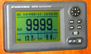 laws from Belize.
The return from Lighthouse Reef to the Drowned Cays was a good fast trip, where the winds and the current cooperated, a forty-six mile trip that took under five hours. The current that flows North along the Belize and Yucatán coast was helping us significantly. <Larry: And we managed to induce a barracuda to join us for dinner, dressed as ceviche.>
While in Belize we passed a momentous milestone. After cruising for almost 6 years we have sailed 10,000 nautical miles! Sure, the big names in sailing have sailed 100,000 or 200,000 miles but we were pleased with our accomplishment. Sailboats our size do not go very fast. We average about 5 or 6 knots when under sail but in our 10,000 miles we had seen a lot of territory with much more to see in our future on Moira.
Cay Caulker and San Pedro (Ambergris Cay)
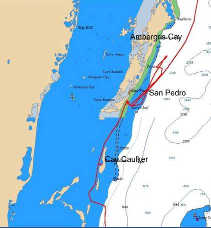 <Larry:
Cay Caulker lies just South of Ambergris Cay, at the northern end of Belize’s
Caribbean coast. Where Caulker is funky and laid-back, San Pedro is more
upscale and relatively polished. Where Caulker has streets that are sand (or
mud, depending on the weather), Ambergris has paved streets. We liked them
both, for different reasons. Certainly, the anchorage at Caulker was more
placid than that at Ambergris (see below). The passage inside the reef from the
West side of Caulker to the East side of Ambergris was shallow, and we often
had inches of water under our keel.
<Larry:
Cay Caulker lies just South of Ambergris Cay, at the northern end of Belize’s
Caribbean coast. Where Caulker is funky and laid-back, San Pedro is more
upscale and relatively polished. Where Caulker has streets that are sand (or
mud, depending on the weather), Ambergris has paved streets. We liked them
both, for different reasons. Certainly, the anchorage at Caulker was more
placid than that at Ambergris (see below). The passage inside the reef from the
West side of Caulker to the East side of Ambergris was shallow, and we often
had inches of water under our keel.
We had several good lunches in restaurants on the (ocean side) beach at Cay Caulker. The big cruise ships that stop at Belize City offer their passengers the option of various day-trips in small boats to places like Cay Caulker. It was both humorous and sad to see the mostly very-overweight North Americans, simultaneously pasty-skinned and sunburned, waddle down the dock and into the restaurants.>
Prior to our departure from Belize we spent several pleasurable days anchored off of San Pedro, Belize’s tourist center, located on the most northernmost cay in Belize, Ambergris Cay. The small town reminded us of San Andrés, a tourist island off of Nicaragua owned by Columbia. Both places have a good deal of upscale North American retail, lots of hotels, and water sports galore. We anchored behind the reef about one quarter mile from shore. The water was shallow, about 10 feet, aquamarine and very clear. Unfortunately, the dive boats and ferries taking off for a fast trip to Belize City or nearby Cay Caulker never heard of a speed limit in an area where boats were anchored. There were about 15 to 20 boats an anchor at any one time, half of them charter boats managed by TMM charters. <Larry: For what it’s worth, we didn’t see any instances of Wrongful Anchoring by the TMM charter boats.> The dive boats and ferries would go like mad through the anchorage causing waves as they passed. The ferries in particular seemed to come as close as possible prior to diverting around one’s boat. Fortunately, the noise and commotion stopped about 6 in the evening, leaving the evening peaceful and without complaints.
Even with the commotion in the anchorage, San Pedro was a pleasant place to visit. There were numerous very good restaurants, and there was the requisite array of shops. Amazingly for a small town, the opportunities to provision were plentiful. Several small grocery stores were in town, catering to the tourist trade and therefore fitting our needs well. Much of Belize’s food is imported from the United States, and these grocery stores were often miniatures of stores in the USA with prices to match. Frozen fish was generally available with many unusual gourmet items from curries and pesto to very good brie cheese. So San Pedro was a treat at the end of our stay <Larry: capped by a couple of fine lunches at the Jamba Jerk Pit on the beach.>
Mr. Fix-It - II
A more substantial repair was required after our first attempt to leave San Pedro. We had officially checked out of Belize, and were about an hour out of San Pedro in fairly boisterous weather when the top of our headsail blew out. Larry, acting fast, was able to get the jib down. <Larry: For the sailors in the audience: The webbing that connected the head of the sail to the top of the roller furler had chafed through. The sail then started to tear down the luff, separating the body of the sail from the boltrope that slid into the furler extrusion, for a distance of maybe 8 feet before we got the sail down.> After getting this huge sail down he stuffed it down the bow hatch where we keep other sails. There was not a lot of room for the jib so Larry was jumping up and down on the sail to get it under control and down the hatch, sort of so to speak. This was a massive job, to say the least. Without the jib available, the boat was at a disadvantage in the weather we had because it had lost the pulling power of the jib. The weather did not look like it was moderating and we were heading toward Mexico with an overnight sail in front of us. Once again, I made the case for turning around while Larry rightly argued for heading toward Mexico, and our next destination of Isla Mujeres, because there was a reportedly a good sail maker there. We eventually turned around and sneaked back into San Pedro, choosing not to inconvenience the overworked officials there with the inconsequential news of our return.
The next morning at anchor, we were able to look closely at the sail, and it became apparent that we might be able to patch the sail in a way that might last long enough to get us to somewhere we could find a real sail maker. Fix it we did, with the sail repair kit Larry had and some assistance from my sewing machine <Larry: and a lot of contact cement!> we patched it up and Larry was able to sew by hand the very heavy head area, replacing the webbing that had chafed through. This was our first experience at a significant sail repair. We felt good about our accomplishment! We did spend one more day at San Pedro resting up and awaiting moderate weather before departing, again without bothering officialdom with the news. Our sail repair was our poster child for those days. <Larry: The repair held as far as Isla Mujeres, Mexico, where we did find a sail maker.>
Our next installment will carry us up the Yucatán Peninsula of Mexico, and will include the Mayan ruins at Tulum and Chichén Itzá.
Additional photos from this trip can be found in our Photo Gallery and Moira’s Ship’s Store.
![]() Rate this page
(CentralAmerica8.htm)
Rate this page
(CentralAmerica8.htm)