The Log of Moira
Western Caribbean: Colombian Islands of San Andrés and Providencia, and Quita Sueño Bank (April-May 2008)
These are mostly Susan’s remarks. Larry’s notes are indicated thus <Larry: blah blah blah.>.

We started traveling north from Panama in late April, as we wanted to reach the Rio Dulce area of Guatemala by about May 30th. By the end of May, the weather begins to deteriorate, with increasing heavy rain and many thunder and lightning storms. The hurricane season officially starts the 1st of June, though the area is usually not affected by hurricanes until late August and September. By the time we reached the Rio Dulce, tropical waves were coming past every few days. Tropical (or “easterly”) waves (disturbances in the atmosphere, not the water) are precursors to tropical depressions, which may grow up to become tropical storms and hurricanes. <Larry: the net of all this was that it was becoming time to ‘git out of Dodge’ if we were going to ‘git’ this season.>
We spent a lot of time discussing how to travel north to the Rio Dulce. There are several traditional routes often followed by cruisers.
<Larry: The beginning of the route goes 200-250 miles northwest from Panama to the neighboring Colombian islands of San Andrés and Providencia. Because of the fees involved (one is required to use an agent to check in to these islands) some cruisers visit one or the other island, or skip both entirely. From either of these islands, there are three general routes around Cabo Gracias a Díos toward the Bay Islands of Honduras.
- One can go NNE in the direction of the Serranilla Bank. In the chart above, the Serranilla Bank is just to the right of the top right corner of the shallow (blue) area in the top center of the chart. One can stop there or not, according to conditions, then proceed WNW, either northeast or southwest of the Rosalind Bank in the direction of Colombian-owned Swan Island, and thence to the Bay Islands. This route involves more on-the-wind sailing, is slightly longer overall than the other two, and takes one far enough north that stopping at Hobbies or Vivarillos Cays is out of one’s way. On the other hand, it avoids the shallow-water sailing that is required by the other two routes. Depending upon the route taken upon leaving the Serranilla Bank, one need not see water shallower than maybe 1000’ deep until the Bay Islands.
- One can go NNE in the direction of the Quita Sueño Bank (again, stopping there or not), thence NW between the Gorda Bank to the north and the Media Luna Cays to the south, thence past the Hobbies/Vivarillos Cays, and thence to the Bay Islands. This is the route we took, and in the relevant section, we saw depths in the 70’-100’ range for about 120 miles.>
- The “Mosquito/Miskito Channel” closely follows the coast of Nicaragua and Honduras. The depths are about the same as in the second option. The channel is relatively narrow, and leads one near a lee shore. We’ve been told that, in some seasons, the channel south and west of the Media Luna Cays is clogged with fishing lines and nets. Many advise against this route because of reported attacks from “pirates” or—more likely—poor fishermen defending their nets close to the coast. We have not heard any reports of “attacks” for several years, but we chose to avoid the coastal route more from concern of the narrow channel and fishing nets than from so-called “pirates”.
Isla San Andrés, Colombia
The weather facilitated our passage from the San Blas of Panama northward, with winds under 25 knots and little rain. We traveled for two nights and almost two days with the wind on our beam, or at times off our bow causing confused seas and the usual noise.
Our first stop was San Andrés, a beautiful island about 9 miles long and a mile wide. San Andrés is 100 miles off the coast of Nicaragua, but is owned and governed by Colombia, almost 400 miles away. <Larry: We had talked about stopping at the Cayos Este-Sudeste (“east-southeast cays”) which, not surprisingly, are just southeast of San Andrés. They were right on our way (we saw the light on Cayo Bolivar as we went past in the pre-dawn light, but by that point in the trip, fatigued as we were, we weren’t eager to try anchoring in unfamiliar reefs.> By the time we were within 30 miles of San Andrés the ocean calmed and the sun shone, making our final miles toward the island pleasant and welcoming. It is always a treat for me to approach our new destination. San Andrés was particularly beautiful and the sea was a gorgeous blueberry blue <Larry: one cruiser described the visual experience as “sailing on lumpy blueberry soup”> with the occasional dolphin thrown in.
 The
process for checking into San Andrés was simple and straightforward. <Larry:
The port captain refuses to deal directly with yachties, and (in common with
mainland Colombia) requires that one use an agent.> The agent from the
Serrana Agency came to the marina, collected our papers and our fee of $40 to
cover both check-in and check-out (plus $15 each for tourist visas that were
also good in Providencia) and brought back to us that afternoon our stamped
passports and a permit from the port captain allowing us to keep Moira
in the Colombian islands (to include Providencia) for 90 days. Cruisers in the
past have recommended the Livingston Agency as well. We were told that Mr.
Livingston had died, and the agency no longer exists. <Larry: The use of an
agent is always a tradeoff: money vs. convenience, yours and the port
captain’s. An agent scoops up your papers, finds all the offices, gets
everything stamped, and returns your papers for a fee. Simple, but we’ve never
found checking in and out to be hard. Time-consuming, perhaps, but not hard.
And many countries, Colombia included, charge no or tiny fees at the government
level. So the $40 we gave the agent went into his pocket. However, when one is required
to use an agent, the decision on the tradeoff has been made for you: the port
captain finds it easier to deal with the agent rather than the scruffy
yachties.>
The
process for checking into San Andrés was simple and straightforward. <Larry:
The port captain refuses to deal directly with yachties, and (in common with
mainland Colombia) requires that one use an agent.> The agent from the
Serrana Agency came to the marina, collected our papers and our fee of $40 to
cover both check-in and check-out (plus $15 each for tourist visas that were
also good in Providencia) and brought back to us that afternoon our stamped
passports and a permit from the port captain allowing us to keep Moira
in the Colombian islands (to include Providencia) for 90 days. Cruisers in the
past have recommended the Livingston Agency as well. We were told that Mr.
Livingston had died, and the agency no longer exists. <Larry: The use of an
agent is always a tradeoff: money vs. convenience, yours and the port
captain’s. An agent scoops up your papers, finds all the offices, gets
everything stamped, and returns your papers for a fee. Simple, but we’ve never
found checking in and out to be hard. Time-consuming, perhaps, but not hard.
And many countries, Colombia included, charge no or tiny fees at the government
level. So the $40 we gave the agent went into his pocket. However, when one is required
to use an agent, the decision on the tradeoff has been made for you: the port
captain finds it easier to deal with the agent rather than the scruffy
yachties.>
This is a tourist island, visited mostly by well-to-do Colombians and the occasional cruiser like ourselves. When we arrived, we talked to another cruiser who was leaving for the next island in the passage north, Providencia, who gave us good suggestions for provisioning and fun, and shared with us that 6 cruisers had just left for points north. We saw several of them in Providencia.
San Andrés has a fine harbor in which we anchored, sharing
it with several cruisers and many fishing boats including 6 or 8 large
shrimpers. The yacht club on the island had a reputation for being rather
snotty and not wanting cruisers around, so we stayed away. We ate lunch one day
at a restaurant next door to the yacht club, and saw very little activity
there.  Nene’s
Marina, near where we anchored, was very basic, mostly consisting of a dinghy
dock that seemed secure, a fuel dock, and a very small restaurant or sandwich
shop. The owners were helpful with advice and the beer was cold.
Nene’s
Marina, near where we anchored, was very basic, mostly consisting of a dinghy
dock that seemed secure, a fuel dock, and a very small restaurant or sandwich
shop. The owners were helpful with advice and the beer was cold.
Provisioning on San Andrés was easy and provided lots of variety. The provisioning seems to be geared to the large expat community from both Costa Rica and the United States. There is also a large, well-to-do Colombian tourist presence that is used to getting American imports in Colombia. The island is also a major SCUBA diving center in this part of the Caribbean, with many divers coming from the United States and Europe, who look for a variety of goods which the local merchants have found profitable to make available here. Several markets were stocked with American brands, even including Pillsbury flour and American brands of peanut butter and breakfast cereal. The Pillsbury flour was several times the cost of the unbranded local flour. The unbranded flour is sold in one-pound unmarked plastic bags but was perfectly good for use. I never buy American peanut butter out here for the same reason: it is very expensive by comparison with the local brands, which are quite good. We discovered that San Andrés is provisioned by ships from Costa Rica with supplies that Costa Rica in turn gets from the United States.
The non-food shopping on the island was also varied and plentiful. San Andrés was once a tax-free zone of Colombia. Now the stores operate much like “power centers” in the States but without the tax breaks once available. There are many specialty retail stores, allowing one to buy everything from expensive, exotic wines to Chanel perfumes and Coach hand bags.
Transportation around the island is mostly by 125cc motorcycles for the locals, and golf carts for the tourists. There are relatively few private or rental cars on the island. We joined the fun and rented a golf cart at $20 an hour. Four hours was more than enough to drive around the island. We enjoyed lunch in the middle of our drive at the Rincon de la Langosta restaurant, overlooking the beautiful western Caribbean sea. We enjoyed shrimp and lobster for lunch, and were able to talk with the restaurant staff about buying shrimp and lobster on the island. These islands are famous for their shrimp but the shrimp season does not start until July 1st in this area of the world so buying from the shrimp boats was not in the plan. Small tiendas served the restaurant’s needs for frozen shrimp and lobster during the off-season. We were unable to find fresh shrimp, though lobster was occasionally offered on the side of the road. It was not clear that the sale was legal, given the seasons for shrimp lobster and crab fishing.
The weather on the island was very pleasant, almost
temperate in comparison to the humidity and heat of Panama. When we were there,
there was a pleasant breeze and temperatures in the 80’s but without the usual
humidity of the  tropics.
Overall, the island reminded me of Puerto Vallarta in the early 1980’s. There are some very good-looking houses on the island which appear to be vacation houses for wealthy Colombians, but most of the island serves the tourist industry and lives at the middle class or lower. We saw very little outright poverty on the island, and none of the shacks of the cities of mainland Colombia. The downtown areas look pretty good with a large variety of goods available. It appears that the city government is paying attention to development and the look and feel of the city, but there is need for an overall clean-up program. Construction sites tend to be full of litter, or else the site next door gets the residue. There is a fair amount of trash on the side of the roads in addition to discarded furniture, plastic and home junk. Cleaning it up would do wonders for the overall look and feel of this place.
The population here is Spanish-speaking and mostly black. Music abounds in festivals and in restaurants and bars. The residents are friendly and move with the ability to dance and an enjoyment of life. <Larry: While we were here, the island celebrated “Children’s Day” with a parade and other festivities.>
Isla Providencia, Colombia
 After
four days on San Andrés we took off for Providencia, about 55nm (a long
daylight trip) away. We were lucky with the wind, with 15 to 18 knots of wind
for a light close-hauled sail in sun and clear skies. Sunny days make for
pleasant sailing and good times on the boat; overcast days are damp and colder,
and often one worries about the weather deteriorating. There was about one-half
knot of current assisting our ride to Providencia. About 4pm we were
approaching the sweet, lovely island of Providencia (“heaven” in Spanish).
After
four days on San Andrés we took off for Providencia, about 55nm (a long
daylight trip) away. We were lucky with the wind, with 15 to 18 knots of wind
for a light close-hauled sail in sun and clear skies. Sunny days make for
pleasant sailing and good times on the boat; overcast days are damp and colder,
and often one worries about the weather deteriorating. There was about one-half
knot of current assisting our ride to Providencia. About 4pm we were
approaching the sweet, lovely island of Providencia (“heaven” in Spanish).
Providencia has a well-marked channel with an inner harbor and an outer harbor. We anchored in about 20 feet of very clear water in the outer harbor, just outside the channel and right off of a small beach and cove which was shaded by both deciduous and pine trees. <Larry: Providencia is technically two islands, Providencia and Santa Catalina, joined by a pontoon bridge. The pair of islands, considered as one, is about 5nm long and 2.5nm wide. We anchored off of Santa Catalina, near a geological formation known as “Morgan’s Head” after the Welsh pirate.>
This island has tourists but not many. There is a small airport, but the residents seem to have no interest in bringing in more tourists by making the airport larger. People here like the quiet, low key feel of the island and don’t want it to change. They realize that that decision limits their income and results in a costly life style where the monthly cost for electricity for a middle class small house runs $70 and water runs $20. <Larry: Essentially everything but fish, coconuts, and bananas is imported into both San Andrés and Providencia. For example, all the diesel fuel to run the islands’ generators comes in by tanker. When you have to amortize the cost of an inter-island freighter over a small amount of goods, the cost of each item goes up considerably. The taxi driver who gave us our tour of the island identified “the cost of living” as the number-one problem on the island.>
 Check
in here is done by the Bush Agency. In fact, it seems that anything to do with
cruisers can be handled by Mr. Bush, an engaging 50-ish fellow who seemed
equally at home in Spanish and English. One could hear in his speech patterns
the years of drill of English phrases. He greeted us with “How are you?” even
if it had been only a few minutes since we had seen him last. We paid Mr. Bush
$50 for his services of checking in and out. There was no additional cost for a
tourist visa (ours from San Andrés were still good) and no cost for the port
captain. Mr. Bush’s wife does laundry.
Check
in here is done by the Bush Agency. In fact, it seems that anything to do with
cruisers can be handled by Mr. Bush, an engaging 50-ish fellow who seemed
equally at home in Spanish and English. One could hear in his speech patterns
the years of drill of English phrases. He greeted us with “How are you?” even
if it had been only a few minutes since we had seen him last. We paid Mr. Bush
$50 for his services of checking in and out. There was no additional cost for a
tourist visa (ours from San Andrés were still good) and no cost for the port
captain. Mr. Bush’s wife does laundry.
Mr. Bush found us a good driver to see the island. (I had tried a motor scooter and decided that I would not survive driving around the island.) We paid our driver $20 a hour for the ride in a classic Lincoln of a 1950’s vintage. <Larry: It was actually from the early 90’s.> It reminded me of pictures I have seen of the cars available in Cuba. We were able to see the island, view the island’s reservoir, and stop at an arts and craft store. We had lunch at Roland’s, a famous and very good Rasta-themed place for a fried fish extravaganza. There we met the young stylish governor of the islands <Larry: San Andrés and Providencia have a joint regional government> who was somehow related to our driver. Providencia is more hilly than San Andrés and has many fine, wide beaches, whereas San Andrés has a volcanic coastline with few, narrow beaches. We enjoyed visiting several small shops in Providencia, including a bakery, a book exchange, and a good French restaurant. We could have easily stayed for several weeks in this very lovely, cozy island. We felt welcomed among these relaxed, helpful residents who, if they did not have something, would always say “Go talk with Mr. Bush.”
We were eager to keep going so that we would have ample time to enjoy the Bay Islands of Honduras.
<Larry: In Providencia we began to notice a growing English influence. The oldest population group here is known as the Raizal, who speak a variant of English Creole, and constitute roughly half the population of the island. We were told that the same ethnic group is present on San Andrés, though we did not remark upon them in our visit there. Generally, the top and bottom classes (Colombian government officials, and the very poor) speak Spanish, and the middle class speaks English.>
Low Cay
 In
addition to the traditional island-hopping that is available, Larry talked me
into stopping at several spots which are uninhabited shallow banks in the
middle of the Caribbean sea on our way as we traveled north. Larry wanted to stop at the banks “because
they were there” and with careful navigation could be safely reached.
<Larry: And it’s difficult for me to resist the lure of any place where we
could be the only boat in the anchorage.> I was less than interested,
because after a passage I want to become a part of a community again, a
community which includes other cruisers and residents of the particular island
or port we visit. <Larry: Besides which, she was apprehensive about the
lines in the Sailing Directions that said that the banks were
“dangerous.” She was worried about what she’d say to our insurance company if
we came to grief upon the banks after having read the Sailing Directions.
Of course the banks are dangerous—so is Florida, if you run into it in the
middle of the night.> So we reached a compromise and agreed to see two of
these banks: Low Cay, just north of Providencia, and Quita Sueño Bank, both off
the coast of Nicaragua.
In
addition to the traditional island-hopping that is available, Larry talked me
into stopping at several spots which are uninhabited shallow banks in the
middle of the Caribbean sea on our way as we traveled north. Larry wanted to stop at the banks “because
they were there” and with careful navigation could be safely reached.
<Larry: And it’s difficult for me to resist the lure of any place where we
could be the only boat in the anchorage.> I was less than interested,
because after a passage I want to become a part of a community again, a
community which includes other cruisers and residents of the particular island
or port we visit. <Larry: Besides which, she was apprehensive about the
lines in the Sailing Directions that said that the banks were
“dangerous.” She was worried about what she’d say to our insurance company if
we came to grief upon the banks after having read the Sailing Directions.
Of course the banks are dangerous—so is Florida, if you run into it in the
middle of the night.> So we reached a compromise and agreed to see two of
these banks: Low Cay, just north of Providencia, and Quita Sueño Bank, both off
the coast of Nicaragua.
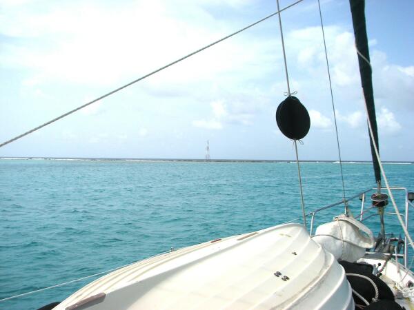
Each of these banks is a coral reef in the middle of the ocean. <Larry: A bank typically has a solid coral reef along its windward (eastern) edge, just below the surface of the ocean. Downwind (west) of the solid reef is an area of several miles of shallow water, perhaps 20-70’ deep, a sandy underwater plateau with numerous coral heads that may rise to within a few feet of the surface. Unless wave action has broken off pieces of the windward reef and piled them up on top of one another to a height above the water level, there is no “land” in sight.> At the point we anchored each time the waters were smooth and the depth was 20 feet or less. And there was nothing visible for miles around.
The banks can provide sheltered anchorages in settled weather. <Larry: Sheltered, that is, from wave action rather than from the wind. In this context, an “anchorage” is simply a clear area large enough to allow your boat to swing on her anchor to any changes in the wind, without the boat running into any coral heads, and without the anchor chain dragging across any coral.> In the clear, settled conditions we had, I could see the passages between the coral heads from my vantage point on top of our dinghy on the cabin top. We had gotten coordinates (latitude/longitude) from Soggy Paws for several suggested entrances from the open sea <Larry: i.e., from the downwind side> and coordinates for the relatively open area in which we anchored. It was the ride from the entrance to the anchorage that was exciting to undertake, as we had to tiptoe around the coral heads. I could see the way but several times I had to yell at Larry to turn sharply to port or starboard. Luckily, he reacted quickly.
We stopped first at Low Cay (pronounced “key”), only about 10 miles from Providencia. This bank has a solid reef on its windward side, the above-water portion of which was about 300 feet long, 30 feet wide, and 3 feet above the water. The reef, both the small above-water part and the extensive undersea parts on either side, acted as a breakwater. I suppose one could walk a dog on the top of the above-water reef if conditions were settled enough to make a dinghy landing feasible. At least there was something to see upon arriving at the anchorage! The coral breakwater supported a light tower, so we could use our RADAR to cross-check the coordinates we had been given.
Quita Sueño Bank
 Low
Cay was a good preparation for the next bank, Quita Sueño (“quit dreaming”) about
50 miles to the north. When we arrived in the anchorage area there was nothing.
The only coral was below the surface, around us in shallow areas. Again we had
coordinates that identified an entrance to the bank and a recommended
anchorage. Our job was to find our way <Larry: tippietoe> into the
recommended anchorage area without running into the coral heads which were
usually visible below the water when we got up close but not from afar. We were
somewhat prepared by our experience at Low Cay, but picking our path required
keeping a careful watch. <Larry: It also required good light (over your
shoulder), and low speed. The good light was almost automatic, given a
reasonably clear sky, because of the geography of all these banks. Because the
barrier reef is on the east side, one must enter from the west, i.e., going
east. So if you arrive in the afternoon, you automatically have light over your
shoulder.> It was both exciting and a little scary, but the anchorage itself
was beautiful, in 20 feet of very clear water. The area was raw, primitive, and
all ocean. There was nothing to see except two wrecks many years old,
off in the distance. The wrecks reminded us of the result if this area is
approached without care, or in a storm.
Low
Cay was a good preparation for the next bank, Quita Sueño (“quit dreaming”) about
50 miles to the north. When we arrived in the anchorage area there was nothing.
The only coral was below the surface, around us in shallow areas. Again we had
coordinates that identified an entrance to the bank and a recommended
anchorage. Our job was to find our way <Larry: tippietoe> into the
recommended anchorage area without running into the coral heads which were
usually visible below the water when we got up close but not from afar. We were
somewhat prepared by our experience at Low Cay, but picking our path required
keeping a careful watch. <Larry: It also required good light (over your
shoulder), and low speed. The good light was almost automatic, given a
reasonably clear sky, because of the geography of all these banks. Because the
barrier reef is on the east side, one must enter from the west, i.e., going
east. So if you arrive in the afternoon, you automatically have light over your
shoulder.> It was both exciting and a little scary, but the anchorage itself
was beautiful, in 20 feet of very clear water. The area was raw, primitive, and
all ocean. There was nothing to see except two wrecks many years old,
off in the distance. The wrecks reminded us of the result if this area is
approached without care, or in a storm.
<Larry: We snorkeled around the boat, marveling at the coral formations on all sides and in the deep water below our keel. However, our swim was cut short when we noticed hundreds of small, transparent jellyfish in the water. Rather than risk a close encounter of an unpleasant kind, we retreated to Moira, to prepare for our next leg, to the Bay Islands of Honduras.
Additional photos from this trip can be found in our Photo Gallery and Moira’s Ship’s Store.
![]() Rate this page
(CentralAmerica2.htm)
Rate this page
(CentralAmerica2.htm)